Description:
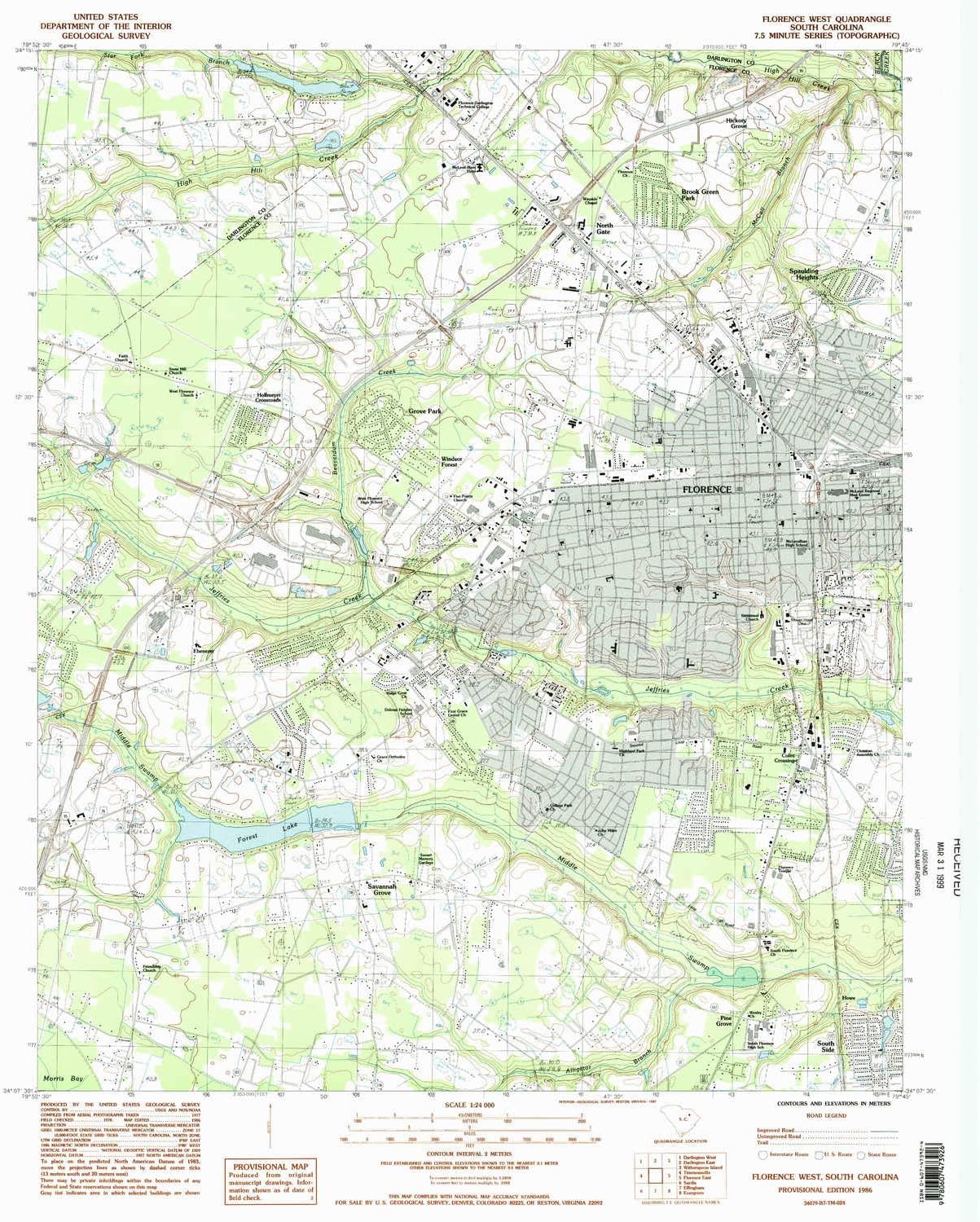
USGS topographic map of Florence West, South Carolina, dated 1986, updated 1987.
Includes geographic coordinates (latitude and longitude), lines of elevation, bodies of water, roads, and more. This topo quad is suitable for recreational, outdoor uses, office applications, or wall map framing.
Printed on-demand by YellowMaps on the print material of your choice.
Shipping rolled from Minneapolis, MN, United States.
Product Number: USGS-5387148
Map Size: 26.7 inches high x 22 inches wide
Map Scale: 1:24000
Map Type: POD USGS Topographic Map
Map Series: HTMC
Map Version: Historical
Cell ID: 15618
Scan ID: 260989
Imprint Year: 1987
Woodland Tint: Yes
Visual Version Number: 2
Aerial Photo Year: 1977
Edit Year: 1986
Field Check Year: 1978
Datum: NAD27
Map Projection: Universal Transverse Mercator
Provisional map: Yes
Map published by United States Geological Survey
Map Language: English
Scanner Resolution: 600 dpi
Map Cell Name: Florence West
Grid size: 7.5 X 7.5 Minute
Date on map: 1986
Geographical region: South Carolina, United States
Northern map edge Latitude: 34.25°
Southern map edge Latitude: 34.125°
Western map edge Longitude: -79.875°
Eastern map edge Longitude: -79.75°
Surrounding map sheets (copy & paste the Product No. in the search bar):
North: USGS-5387012,USGS-5387014
East: USGS-5387146
South: USGS-5387094
West: USGS-5388418
Details:
Visit the YellowMaps Store
Florence West SC topo map, 1:24000 Scale, 7.5 X 7.5 Minute, Historical, 1986, Updated 1987, 26.7 x 22 in
BHD4124

Quantity:
Order today to get by 7-14 business days
This item qualifies for free delivery
 Imported From: United States
At BOLO, we work hard to ensure the products you receive are new, genuine, and sourced from reputable suppliers.
Every product in the BOLO catalogue is sourced through our Verified Global Supply Network of verified sellers, authorized distributors or directly from the manufacturer.
Each product undergoes thorough inspection and verification at our consolidation and fulfilment centers to ensure it meets our strict authenticity and quality standards before being shipped and delivered to you.
If you ever have concerns regarding the authenticity of a product purchased from us, please contact Bolo Support. We will review your inquiry promptly and, if necessary, provide documentation verifying authenticity or offer a suitable resolution.
Your trust is our top priority, and we are committed to maintaining transparency and integrity in every transaction.
While we strive to display accurate information, variations in packaging, labeling, instructions, or formulation may occasionally occur due to regional differences or supplier updates. For detailed or manufacturer-specific information, please contact the brand directly or reach out to BOLO Support for assistance.
Unless otherwise stated, all prices displayed on the product page include applicable taxes and import duties.
BOLO operates in accordance with the laws and regulations of Bahrain. Any items found to be restricted or prohibited for sale within the Bahrain will be cancelled prior to shipment. We take proactive measures to ensure that only products permitted for sale in Bahrain are listed on our website.
All items are shipped by air, and any products classified as “Dangerous Goods (DG)” under IATA regulations will be removed from the order and cancelled.
All orders are processed manually, and we make every effort to process them promptly once confirmed. Products cancelled due to the above reasons will be permanently removed from listings across the website.
Share with
Or share with link
https://www.bolo.bh/products/UO07Y2P9XOX
Visit the YellowMaps Store
Florence West SC topo map, 1:24000 Scale, 7.5 X 7.5 Minute, Historical, 1986, Updated 1987, 26.7 x 22 in
BHD4124
Quantity:
Order today to get by 7-14 business days
This item qualifies for free delivery
Imported From: United States
At BOLO, we work hard to ensure the products you receive are new, genuine, and sourced from reputable suppliers.
Every product in the BOLO catalogue is sourced through our Verified Global Supply Network of verified sellers, authorized distributors or directly from the manufacturer.
Each product undergoes thorough inspection and verification at our consolidation and fulfilment centers to ensure it meets our strict authenticity and quality standards before being shipped and delivered to you.
If you ever have concerns regarding the authenticity of a product purchased from us, please contact Bolo Support. We will review your inquiry promptly and, if necessary, provide documentation verifying authenticity or offer a suitable resolution.
Your trust is our top priority, and we are committed to maintaining transparency and integrity in every transaction.
While we strive to display accurate information, variations in packaging, labeling, instructions, or formulation may occasionally occur due to regional differences or supplier updates. For detailed or manufacturer-specific information, please contact the brand directly or reach out to BOLO Support for assistance.
Unless otherwise stated, all prices displayed on the product page include applicable taxes and import duties.
BOLO operates in accordance with the laws and regulations of Bahrain. Any items found to be restricted or prohibited for sale within the Bahrain will be cancelled prior to shipment. We take proactive measures to ensure that only products permitted for sale in Bahrain are listed on our website.
All items are shipped by air, and any products classified as “Dangerous Goods (DG)” under IATA regulations will be removed from the order and cancelled.
All orders are processed manually, and we make every effort to process them promptly once confirmed. Products cancelled due to the above reasons will be permanently removed from listings across the website.
Description:
USGS topographic map of Florence West, South Carolina, dated 1986, updated 1987.
Includes geographic coordinates (latitude and longitude), lines of elevation, bodies of water, roads, and more. This topo quad is suitable for recreational, outdoor uses, office applications, or wall map framing.
Printed on-demand by YellowMaps on the print material of your choice.
Shipping rolled from Minneapolis, MN, United States.
Product Number: USGS-5387148
Map Size: 26.7 inches high x 22 inches wide
Map Scale: 1:24000
Map Type: POD USGS Topographic Map
Map Series: HTMC
Map Version: Historical
Cell ID: 15618
Scan ID: 260989
Imprint Year: 1987
Woodland Tint: Yes
Visual Version Number: 2
Aerial Photo Year: 1977
Edit Year: 1986
Field Check Year: 1978
Datum: NAD27
Map Projection: Universal Transverse Mercator
Provisional map: Yes
Map published by United States Geological Survey
Map Language: English
Scanner Resolution: 600 dpi
Map Cell Name: Florence West
Grid size: 7.5 X 7.5 Minute
Date on map: 1986
Geographical region: South Carolina, United States
Northern map edge Latitude: 34.25°
Southern map edge Latitude: 34.125°
Western map edge Longitude: -79.875°
Eastern map edge Longitude: -79.75°
Surrounding map sheets (copy & paste the Product No. in the search bar):
North: USGS-5387012,USGS-5387014
East: USGS-5387146
South: USGS-5387094
West: USGS-5388418
Details:
Share with
Or share with link
https://www.bolo.bh/products/UO07Y2P9XOX